Myanmar (Burma)
(Burmah, Birma, Birmanie, Birmania, Bermah)
Myanmar lies at the crossroads of Asia’s greatest civilizations, China and India. Before 1989, Myanmar is known under different names: Suvanabhumi, Bermah, and Burma. It was well known for its ancient archaeology and rich culture. Myanmar stretches from the islands of the Andaman Sea in the south, right up into the Eastern Himalayan mountain range, giving a variety of marvellous people and enriched nature.
There are seven states and seven divisions in Myanmar. The divisions are Ayeyarwady, Bago, Magway, Mandalay, Sagaing, Tanintharyi, Yangon and the states are Chin State, Kachin State, Kayin State, Kayah State, Mon State, Rakhine State, Shan State.
The Independence day is 4th January 1948. There are over 40 foreign missions all over the world, including Embassies, and Consulate Generals. The currency is Kyats. Yangon International Airport and Mandalay International Airport serve as the main airports of Myanmar.
We have 205 guests and no members online

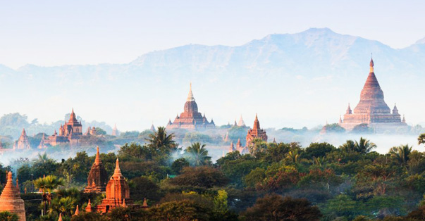
Golden Land Myanmar
- Details
- Last Updated: 15 November 2018
Myanmar, formerly known as Burma. is recognized by the world as the Golden Land. It is one of the earliest homes of mankind. where one can have exclusive experiences of a life-time. You have to find out why.Myanmar. officially Union Of Myanmar. also called Burma. Burmese Myanmar. or Pyidaungzu Myanmar Naingngandaw. is a country lying along the eastern coasts of the Bay of Bengal and the Andaman Sea in southeast Asia.
User Rating: 4 / 5


- Hits: 9938
National Telephone Area Code
- Details
- Last Updated: 15 November 2018
User Rating: 4 / 5
- Hits: 16427

Sittaung River
- Details
- Last Updated: 15 November 2018
Sittaung river lies in east-central Myanmar. rising northeast of Yamethin on the edge of the Shan Plateau and flowing south for 260 miles (420 km) to empty into the Gulf of Martaban of the Andaman Sea. The broad Sittaung River valley lies between the forested Bago Mountains on the west and the steep Shan Plateau on the east and holds the main road and railway from Yangon (Rangoon) to Mandalay as well as the major towns of Bgo. Taungoo. Yamethin. and Pyinmana.
User Rating: 5 / 5
- Hits: 4258

Thanlwin River
- Details
- Last Updated: 15 November 2018
The Thanlwin River (formerly named as Salween or Salwin) rises in Tibet. after which it flows through Yunnan. where it is known as the Nujiang river. although either name can be used for the whole river.
User Rating: 4 / 5
- Hits: 8577
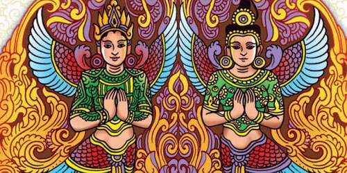
Myanmar Arts
- Details
- Last Updated: 15 November 2018
User Rating: 4 / 5
- Hits: 7753

Flags of Myanmar from time to time
- Details
- Last Updated: 15 November 2018
1948-1974
The big star was meant for the Union. and 5 smaller stars were for 5 states.
User Rating: 3 / 5
- Hits: 4483

Thailand and Myanmar
- Details
- Last Updated: 15 November 2018
A unified Thai kingdom was established in the mid-14th century. Known as Siam until 1939. Thailand is the only Southeast Asian country never to have been taken over by a European power. A bloodless revolution in 1932 led to a constitutional monarchy. In alliance with Japan during World War II. Thailand became a US ally following the conflict. The country is located in Southeastern Asia. bordering the Andaman Sea and the Gulf of Thailand. southeast of Myanmar. The land has a total area of about 514.000 sq km. The border countries are Myanmar. Cambodia. Laos and Malaysia.
User Rating: 5 / 5
- Hits: 1612
Facts about Myanmar
- Details
- Last Updated: 15 November 2018
User Rating: 5 / 5
- Hits: 4186

Myanmar or Burma ?
- Details
- Last Updated: 28 October 2021
"Myanmar" was formerly known as "Burma" until it was changed by the ruling military government after the uprising in 1989.
User Rating: 5 / 5
- Hits: 1519

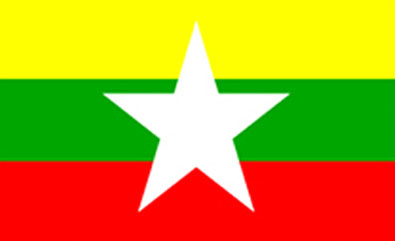
National Flag of Myanmar
- Details
- Last Updated: 15 November 2018
Myanmar. officially the Republic of the Union of Myanmar. adopted a new state flag on 21 October 2010 to replace the former flag in use since 1974.
User Rating: 3 / 5
- Hits: 4359
Mayanmar
- Details
- Last Updated: 15 November 2018
Mayanmar is a very commonly misspelled word, referring to the southeast Asian nation called Myanmar.
User Rating: 5 / 5
- Hits: 2818

Flowers of Myanmar
- Details
- Last Updated: 15 November 2018
Myanmar has a moderate climate and is also rich in different species of flowers.Here are some of the flowers found in Myanmar.
User Rating: 4 / 5
- Hits: 8269

4,000 Myanmar web sites
- Details
- Last Updated: 15 November 2018
User Rating: 5 / 5
- Hits: 4345

Email & Internet Services
- Details
- Last Updated: 15 November 2018
Email & Internet Tariff
User Rating: 3 / 5
- Hits: 4165

Brunei Darussalam and Myanmar
- Details
- Last Updated: 15 November 2018
The Sultanate of Brunei's influence peaked between the 15th and 17th centuries when its control extended over coastal areas of northwest Borneo and the southern Philippines. Brunei subsequently entered a period of decline brought on by internal strife over royal succession. colonial expansion of European powers. and piracy. In 1888. Brunei became a British protectorate; independence was achieved in 1984. The same family has ruled Brunei for over six centuries. Brunei benefits from extensive petroleum and natural gas fields. the source of one of the highest per capita GDPs in the developing world.
User Rating: 5 / 5
- Hits: 2157
Fax Services
- Details
- Last Updated: 15 November 2018
User Rating: 4 / 5
- Hits: 4872

Cambodia and Myanmar
- Details
- Last Updated: 15 November 2018
Most Cambodians consider themselves to be Khmers. whose Angkor Empire extended over much of Southeast Asia and reached its zenith between the 10th and 13th centuries. Subsequently. attacks by the Thai and Cham (from present-day Vietnam) weakened the empire ushering in a long period of decline.
User Rating: 5 / 5
- Hits: 1349
Myanmar Rivers
- Details
- Last Updated: 15 November 2018
User Rating: 4 / 5
- Hits: 6113

Indonesia
- Details
- Last Updated: 15 November 2018
The Dutch began to colonize Indonesia in the early 17th century; the islands were occupied by Japan from 1942 to 1945. Indonesia declared its independence after Japan's surrender. but it required four years of intermittent negotiations. recurring hostilities. and UN mediation before the Netherlands agreed to relinquish its colony.
User Rating: 5 / 5
- Hits: 1394
Ecology & Environment
- Details
- Last Updated: 15 November 2018
User Rating: 5 / 5
- Hits: 3344

Laos and Myanmar
- Details
- Last Updated: 15 November 2018
Laos was under the control of Siam (Thailand) from the late 18th century until the late 19th century when it became part of French Indochina. The Franco-Siamese Treaty of 1907 defined the current Lao border with Thailand. In 1975. the Communist Pathet Lao took control of the government. ending a six-century-old monarchy. Initial closer ties to Vietnam and socialization were replaced with a gradual return to private enterprise. a liberalization of foreign investment laws. and the admission into ASEAN in 1997.
User Rating: 5 / 5
- Hits: 1392

Old National Flag of Myanmar
- Details
- Last Updated: 15 November 2018
The State Flag is rectangular in shape and its background colour is red with a dark blue canton at the top left corner. A pinion and ears of paddy encircled with fourteen white stars of equal size have been superimposed on the dark blue field of the canton.
User Rating: 4 / 5
- Hits: 4842

Malaysia and Myanmar
- Details
- Last Updated: 15 November 2018
User Rating: 5 / 5
- Hits: 1794

Ayeyarwaddy River
- Details
- Last Updated: 15 November 2018
The Ayeyarwady River (formerly known as the Irrawaddy River) flows through the centre of Myanmar. It is Myanmar's most important commercial waterway. Its total drainage area is about 158.700 square miles (411.000 square km). It is about 1.550 km (960 miles) long.
User Rating: 4 / 5
- Hits: 5963

Philippines and Myanmar
- Details
- Last Updated: 15 November 2018
The Philippine Islands became a Spanish colony during the 16th century; they were ceded to the US in 1898 following the Spanish-American War. In 1935 the Philippines became a self-governing commonwealth. Manuel Quezon was elected President and was tasked with preparing the country for independence after a 10-year transition. In 1942 the islands fell under Japanese occupation during WWII. and US forces and Filipinos fought together during 1944-45 to regain control. On 4 July 1946 the Philippines attained their independence.
User Rating: 5 / 5
- Hits: 1277

Chindwin River
- Details
- Last Updated: 15 November 2018
The Chindwin River is a river in Myanmar and the major tributary of the Ayeyarwaddy River. The river flows 840 kilometres to join the Ayeyarwaddy.
User Rating: 3 / 5
- Hits: 3980

Singapore and Myanmar
- Details
- Last Updated: 15 November 2018
User Rating: 5 / 5
- Hits: 1752

National Emblem
- Details
- Last Updated: 15 November 2018
User Rating: 5 / 5
- Hits: 2953

Vietnam and Myanmar
- Details
- Last Updated: 15 November 2018
The conquest of Vietnam by France began in 1858 and was completed by 1884. It became part of French Indochina in 1887. Independence was declared after World War II. but the French continued to rule until 1954 when they were defeated by Communist forces under Ho Chi MINH. who took control of the North.
User Rating: 5 / 5
- Hits: 1706
Myanmar History
- Details
- Last Updated: 15 November 2018
User Rating: 4 / 5
- Hits: 3873
Environment
- Details
- Last Updated: 15 November 2018
From the snow-capped Himalayas in the north to the coral-fringed Mergui Archipelago in the south. Myanmar's 2000-km length crosses three distinct ecological regions within the vast Indo-Malay bio geographic realm: the Indian sub region along the Bangladesh and India borders; the Indochinese sub region in the north bordering Laos and China; and the Syndic sub region bordering peninsular Thailand. Together these regions produce what is quite likely the richest biodiversity in South-East Asia.
User Rating: 5 / 5
- Hits: 2870
